"In early 2017, the Bangkok office of the Thailand Tourism Authority of Thailand (TAT) released a series of eight walking maps for Bangkok. I posted these on my Facebook page and on Twitter, and even though they were only in Thai, they received a lot of interest. TAT officials told me that they will release an English version later this year. What you will find on this page are these maps with links to bigger images. I’ve translated the “places of interest” and also made Google Map versions. In addition, I decided to use these maps as an inspiration to produce my own online walking maps. I will add links to these below as and when I get time. I am working on Map #5 at the moment."
----
Walking Bangkok Map 1: Yaowarat

Points of Interest:
1. Yaowarat Chinatown Heritage Museum
2. Chinatown Gate
3. Easae Coffee Shop
4. Tang Toh Kang Gold Shop
5. Thai Heng Restaurant
6. Wat Bampen Chine Prote
7. Wat Kanmatuyaram
8. Wat Mangkon Kamalawat
9. Leng Buai Yai Shrine
10. Kuam Im Shrine
Walking Bangkok Map 2: Nang Loeng

The second walk starts in Dusit district which is the heart of government offices and royal palaces. It then moves south to the Nang Loeng community, named after the oversized Mon-style jars.
Points of Interest:
1. Royal Plaza
2. Paruskawan Palace
3. Police Museum
4. Marble Temple
5. Nang Loeng Market
6. Shrine
7. Chaloem Thani
8. Wat Sunthon Thammathan
9. Ban Silpa
10. Ban Ten Ram
11. Ban Narasilp
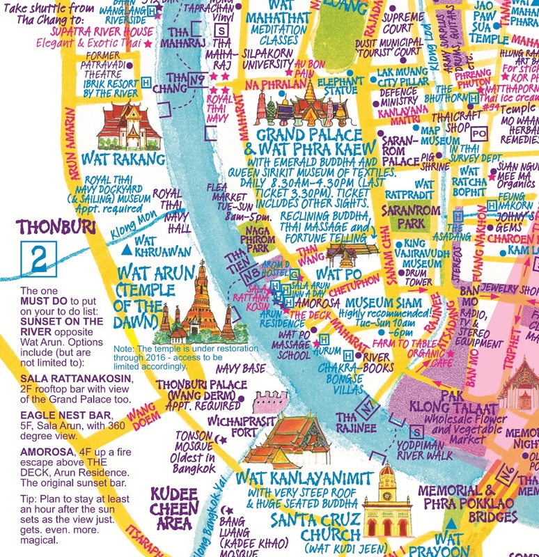
Walking Bangkok Map 3: Thonburi

This third walk is on the Thonburi side of the Chao Phraya River. Less developed than downtown Bangkok, this area still maintains some of its original charms from when it used to be the capital of Thailand.
Points of Interest:
1. Ayutthaya Boat Noodles
2. Wat Arun (Temple of Dawn)
3. Bang Luang Mosque
4. Wat Kalayanamit
5. Kuan Yin Shrine
6. Church of Santa Cruz
7. Wat Prayurawongsawas Waraviharn
8. Goowatin Mosque
9. Princess Mother Memorial Park
10. Wat Anongkharam Worawihan
11. Wat Phitchaya Yatikaram Worawiharn
Walking Bangkok Map 4: Bang Lamphu, Wangna & Tha Tien

This is the fourth walking map which is at the heart of Rattanakosin island. It skirts around the Grand Palace but never goes in. The start is in Bang Lamphu and finishes to the south at Tha Tien.
1. Phra Nakhon Museum
2. Banglamphu Museum
3. Coin Museum
4. Koh Lanta Pizza
5. Wat Mahathat
6. Thawornwatthu Building
7. Hall of Sculpture
8. Tha Tien Market
Walking Bangkok Map 5: Central Rattanakosin

The fifth map takes us through the central part of Rattanakosin island. This is the old part of the city which has been mainly left untouched due to royal influence. The starting point is the Giant Swing, a symbol of Bangkok.
Points of Interest:
1. Giant Swing
2. Trok Mor (morning market)
3. Bamrungchat Satsanayathai Pharmacy
4. Suthattepwararam Temple
5. Thep Monthian Hindu Temple
6. Devasathan (Brahmin Temple)
7. Sam Phraeng
8. Tiger God Shrine
9. Wat Thepthidaram
10. Mahakan Fort
11. Loha Prasat Metal Castle
12. Baan Dinso Boutique Hostel
Walking Bangkok Map 6: Samsen and Thewet

This is the sixth walking map. This area was originally settled by Portuguese farmers and fishermen during the Ayutthaya period. They built the first Catholic church in Bangkok here 335 years ago. Khmer Catholics also later settled here.
Points of Interest:
1. Mae Tuptim Shrine
2. Talad Ban Yuan
3. Saint Francis Xavier Church
4. Conception Church
5. Wat Rachathiwat Ratchaworawihan
6. Wat Thewarat Kunchorn Worawihan
7. Thewet Market
Walking Bangkok Map 7: Bang Rak and Silom

The seventh walking map is in Bang Rak district. This area was settled by Westerners during the reign of King Rama IV. The first embassies and consulates were here. Bangkok’s first modern road, Charoen Krung, also passed through this district which led to its popularity.
Points of Interest:
1. Sathon Pier
2. Chinese Shrine
3. Wat Suan Phlu
4. Assumption Cathedral
5. Old Customs House
6. Haroon Mosque
7. Bangkok General Post Office
8. Bangkok Folk Museum
9. Sueb Sampanthawong Church
10. Sri Maha Mariamman Temple
Walking Bangkok Map 8: Bobe Market and Ratchaprasong

The eighth and last walking map in this series starts at Bobe market, but ends up in the heart of Bangkok’s main shopping district of Ratchaprasong.
Points of Interest:
1. Bobe Market
2. Railway Outdoor Museum
3. Nonthee House
4. Wat Chamnihattakan
5. Jami Ul Khoy Riyah Mosque
6. Silk Community
7. Chalermla Park
8. Bangkok Art and Culture Centre
9. Wat Pathumwanaram
10. Ratchaprasong Junction
http://www.thailandphotomap.com/bangkok-walking-maps/
----
Here is the link for map number 5, which Richard Barrow is working on. It is complex, but he has included some GPS coordinates to help you find some landmarks. A herculean effort! If the TAT ever do eventually publish an English version, I will try and post it here.
http://www.thailandphotomap.com/walking ... tanakosin/